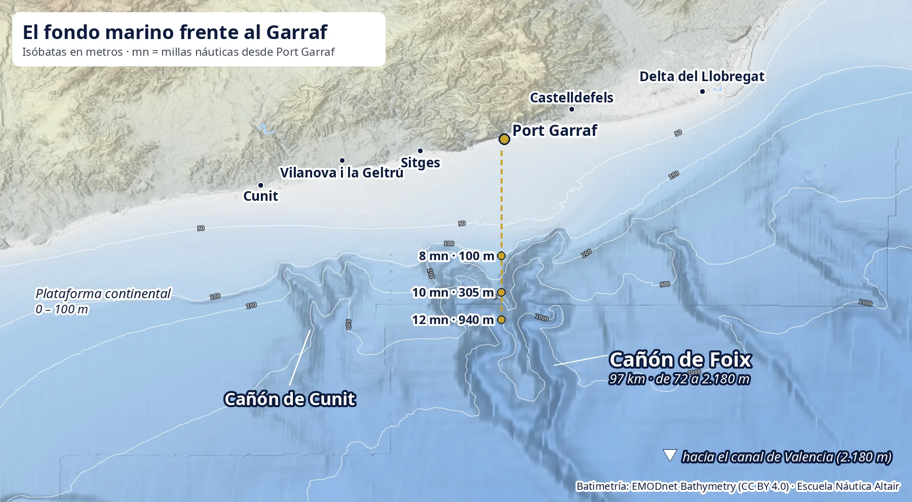
When you sail south out of Port Garraf, the water looks the same colour for hours. Below it, though, something huge is going on: about 8 miles out the continental shelf ends and the seabed plunges down a canyon system that reaches 2,180 metres. It is one of the most spectacular seabed features in the western Mediterranean, and it is the reason fin whales come to feed off Barcelona.
The map: what lies under the water off the Garraf
The map above is built from EMODnet bathymetry data, the European Union's seabed model, the same one used by the nautical chart in our online classroom. The white lines are isobaths, the contour lines of the sea: 50, 100, 200, 500 and 1,000 metres.
Look at two things. First, the light strip along the coast: that is the continental shelf, a gentle plain no deeper than 100 m. Second, the dark shapes twisting southwards: those are the canyons, biting into the edge of the shelf like the roots of a tree.
| Distance from Port Garraf | Depth | What is there |
|---|---|---|
| 3 miles | 37 m | Continental shelf |
| 7 miles | 88 m | Shelf, near the edge |
| 8 miles | 100 m | Shelf edge |
| 10 miles | 305 m | Canyon heads |
| 12 miles | 940 m | Inside the Foix system |
In four miles, less than an hour under sail, the seabed drops almost 900 metres. From the deck you notice nothing; for marine life it changes everything.
The Foix Canyon: a river under the sea
The star of the show is the Foix Canyon System, named after the river that reaches the sea at Cubelles. According to the most complete study published on it, by the Marine Geosciences group of the University of Barcelona (Tubau, Lastras, Canals, Micallef and Amblas, Geomorphology, 2013), the system:
- Runs 97 km from northwest to southeast.
- Starts at 72 m deep, on the continental shelf.
- Ends at 2,180 m, where it joins the Valencia Channel, the great submarine valley between the mainland and the Balearic Islands.
- Has two very sinuous main branches and two tributaries partly filled with sediment: the Cunit and Valldepins canyons.
- Is made of 1,660 channels adding up to about 1,000 km: a network of submarine gullies branching like a mountain river.
In 2009 the research vessel Hespérides mapped the canyon in detail, on a survey led by Professor Miquel Canals within the European Hermione project. In other words, what you see on the map is not a curiosity: it is a first-class scientific subject, an hour's sail from our pontoon.
How it formed: when the Llobregat flowed out there
A submarine canyon looks a lot like a river valley, and not by chance. According to the Barcelona Science Park, the Foix Canyon is where the Llobregat river reached the sea thousands of years ago.
The explanation is sea level. During the ice ages, with much of the planet's water frozen in the ice sheets, the Mediterranean was more than a hundred metres lower than today. The shelf we now sail over was dry land and the coast lay next to the canyon heads. Rivers dumped their sand and silt straight onto the edge of the slope.
That sediment does not stay put: it builds up, becomes unstable and slides down the slope as turbidity currents, underwater avalanches of particle-laden water that scour the seabed like a flash flood. The authors of the 2013 study explain that the small gullies around the canyon heads (the so-called rim gullies) are the main way the canyon grows and eats into the shelf, carrying material from the coast to the deep.
With the sea at today's level, rivers no longer reach that far, which is why the Cunit and Valldepins tributaries are partly filled in. But the landscape is still there, and it still moves water.
Why the canyons attract whales
Here is the reason for it all. A study published in Frontiers in Marine Science (Tort Castro et al., 2022) describes a fin whale feeding ground discovered in the last decade off the Catalan coast, between Torredembarra and Castelldefels, right above the Cunit and Foix canyons. In the authors' words, the canyon systems and the Liguro-Provençal-Catalan current create an upwelling that boosts plankton production in spring, with high krill densities along the shelf edge.
Put simply: the current hits the seabed relief, deep, cold, nutrient-rich water rises, plankton blooms and krill gathers right along the line where the seabed drops away. And the fin whale, the second largest animal on the planet, comes to eat it.
- When: fin whales visit the area from February to June, peaking in April.
- How many: between March and May 2021 the study team recorded 149 sightings of 187 fin whales in this area.
- Who else: Risso's dolphins are also seen over the Garraf canyons, and sperm whales use the canyons of the northwestern Mediterranean as stopovers. SUBMON's SCARS project documents possible resightings of the same sperm whale between Cap de Creus and the Garraf 11 years apart.
The same study warns of a risk: shipping traffic from the port of Barcelona. Since 1986 at least four dead fin whales have been found in the port after collisions with ships, and between 2018 and 2021 seven live whales with injuries were documented. That is why a sailboat, quiet and slow, following the whale-watching rules, is the best way to approach them.
The Garraf on land: a block of limestone
What lies under the water continues on land. The Garraf massif is a huge block of Mesozoic rock, almost horizontal and tilted slightly to the southwest. From bottom to top, according to the Catalan Government's inventory of sites of geological interest:
- At the base, Palaeozoic rocks.
- Above them, Triassic limestones and sandstones, exposed mainly in the eastern sector.
- And capping it all, a thick, compact layer of Jurassic and Cretaceous dolomites and limestones: the white and grey rocks of the cliffs you see from the boat as you leave port.
Limestone has a weakness: rainwater, slightly acidic, dissolves it. Over millions of years that dissolution has turned the Garraf into a karst: a landscape of sinkholes, limestone pavements and more than 400 shafts and caves. Hardly any water runs on the surface; the mountain swallows it.
Underground rivers: fresh water flowing out below the sea
Where does all that water go? To the sea, but underneath. The best-known example is the Falconera cave, in the cliffs between Garraf and Sitges, which you will see to port as soon as you leave the harbour. According to the Barcelona Provincial Council's heritage inventory:
- The Falconera underground river is the most important submarine spring along these cliffs.
- It is about 600 metres long and has been explored to 81 metres below sea level.
- It discharges about 500 litres of fresh water per second on average: 200 in the dry season and up to 10,000 in big floods.
- In 1899 Eusebi Güell had galleries and a well dug to make use of that flow.
In other words, off the Garraf the sea receives fresh water from the rock, below the surface. The rain that falls on the mountain ends up, along invisible paths, in the same sea where the fin whales feed.
From the map to the boat
You can see all this, or rather sense it, from a sailboat. On our whale-watching trips we leave Port Garraf, pass the Falconera cliffs and sail towards the edge of the shelf, where the food gathers. The boat's depth sounder shows you live how the seabed falls away. And in spring, with luck, a five-metre blow appears on the horizon.
If you want to know more about the animals you will be looking for, read our guide to the whales and dolphins of Barcelona. And if you are a researcher and need an equipped boat to work over these canyons, see our vessel for scientific expeditions.
Frequently asked questions
What is a submarine canyon?
A deep valley cut into the continental slope, the step that separates the shelf (down to about 100-200 m) from the abyssal plains. Canyons work like rivers under the sea: they channel sediment, cold water and nutrients between the coast and the deep.
How deep is the Foix Canyon?
The Foix Canyon System runs 97 km from northwest to southeast: it starts at 72 m on the shelf off the Garraf and ends in the Valencia Channel at 2,180 m (Tubau et al., Geomorphology, 2013).
How far from Port Garraf do the canyons start?
Heading south, the seabed reaches 100 m about 8 nautical miles from Port Garraf, 305 m at about 10 miles and around 940 m at about 12 miles (EMODnet bathymetry). In 4 miles the bottom drops almost 900 metres.
Why are there whales off the Garraf?
Because the Foix and Cunit canyons, together with the Liguro-Provençal-Catalan current, cause upwelling of deep, nutrient-rich water. In spring this triggers plankton production and high densities of krill along the shelf edge: food for the fin whale, which visits the area from February to June.
Are there underground rivers in the Garraf?
Yes. The Garraf is a heavily karstified limestone and dolomite massif with more than 400 shafts and caves. The Falconera underground river, by the Garraf cliffs, is about 600 m long, has been explored to 81 m below sea level and discharges fresh water into the sea: about 500 litres per second on average and up to 10,000 in floods.
Sources
- Tubau, X., Lastras, G., Canals, M., Micallef, A. and Amblas, D. (2013). Significance of the fine drainage pattern for submarine canyon evolution: The Foix Canyon System, Northwestern Mediterranean Sea. Geomorphology, 184.
- Tort Castro, B. et al. (2022). Ship Strike Risk for Fin Whales off the Garraf Coast, Northwest Mediterranean Sea. Frontiers in Marine Science, 9.
- Barcelona Science Park (2009). Miquel Canals coordinates the mapping of the Foix submarine canyon (in Spanish).
- SUBMON. The SCARS project confirms connectivity between submarine canyons.
- Catalan Government. Inventory of sites of geological interest: the Garraf massif (in Catalan).
- Barcelona Provincial Council. Heritage inventory: the Falconera underground river (in Catalan).
- Bathymetry: EMODnet Bathymetry (CC BY 4.0).